

Ile de Port-Cros
Port Cros est situé entre Porquerolles et l'île du Levant, c'est la plus petite des trois îles d'Or du golfe de Hyères. Avec ses 4 km de long et 3 km de large, son territoire s'étend sur 690 hectares.
L'île possède cinq forts qui témoignent de la vocation défensive de Port Cros au temps jadis. Le plus ancien date de François I° (le Fort du Moulin). Seuls deux Forts sont ouverts au public: le Fort de l'Eminence et le Fort de l'Estissac, qui est le point idéal pour admirer la plus grande partie de l'île.
Depuis 1963, l'île toute entière est érigée en Parc National et englobe (cas unique en Europe) une zone maritime de 600 mètres autour de ses rivages. Dans une eau d'une limpidité extraordinaire, un "circuit" sous marin est balisé à la manière des sentiers de grande randonnée pédestre. Ce sentier vous fera découvrir la splendeur et la richesse des fonds sous-marins mais attention, les poissons et espèces végétales sont protégés...pas question de pêche sous-marine!La visite est guidée et gratuite, prévoir masque, palmes et tuba. Cette découverte sous-marine se trouve sur la plage de La Palud.
Les vrais amoureux de la nature seront comblés par les nombreuses espèces rares et sauvages qui sont ici protégés et qu'ils découvriront grâce à des sentiers balisés (+de 35 km) sur toute l'île. Ils découvriront en particulier le sentier botanique avec émerveillement et pourrons aussi découvrir les paysages de Port Cros par le circuit des crêtes, le circuit de Port Man, ou celui de la plage.
Pour plus d'informations: http://www.portcrosparcnational.fr/accueil/
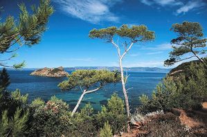
Port Cros is located between Porquerolles and “l'Ile du Levant”, it is the smallest of the three golden islands of the Hyères gulf. With its 2.5 miles long and 1.8 miles wide, it extends over 1705 acres.
The island features five forts which attest the defensive vocation of Port Cros in these days. The oldest was built by François I ° (the Fort of the Mill). Only two
Forts are opened to the public: “Fort de l'Eminence” and “Fort de Estissac”, which is the ideal position to look down on the largest part of the island.
Since 1963, the whole island is set up as National park and contains (unique case in Europe) a maritime zone of 1970 feet around its banks. In a water of an extraordinary clearness, an “aquatic circuit" is marked out in the way trails of the best pedestrian hike. This itinerary will make you discover the magnificence and the abundance of the sea bed but be careful, fishes and botanical species are protected... underwater fishing is out of the question! The visit is guided and free, think to bring masks, flippers and snorkel. This submarine visit starts from "Palud beach".
The true nature lovers will be fulfilled satisfied by numerous rare, wild and protected animal species which can be discovered thanks to the paths marked out (over 21.7 miles) on the island. They will especially discover with delight the botanical path and can also observe the landscapes of Port Cros thanks to the circuit of crests, the circuit of Port Man, or the circuit of the beach.
For more information : http://www.portcrosparcnational.fr/accueil/